
Picard Supɔw (Island)
- Wɔakyerɛw nsɛm yi wɔ Akuapem kasa mu
 Picard Island | |
| Asase ho Nsɛm (Geography) | |
|---|---|
| Beaeɛ a ɛwɔ | Indian Ocean |
| Coordinates | 09°22′S 46°13′E / 9.367°S 46.217°ECoordinates: 09°22′S 46°13′E / 9.367°S 46.217°E |
| Nsupɔw so (Archipelago) | Seychelles |
| Ɛbɛn (Adjacent to) | Indian Ocean |
| Supɔw Dodoɔ | 1 |
| Major islands |
|
| Area | 9.287 km2 (3.586 sq mi) |
| Ntwemu (Length) | 3.2 km (1.99 mi) |
| ne tɛtrɛtɛ (Width) | 3.9 km (2.42 mi) |
| Mpoano (Coastline) | 25.80 km (16.031 mi) |
| Beae a ɛkorɔn sen biara (Highest elevation) | 16 m (52 ft) |
| Nsɛntitiriw a ɛkorɔn sen biara (Highest point) | unnamed dune |
| Adwumayɛ ho nhyehyɛe (Administration) | |
Seychelles
| |
| Ekuo (Group) | Outer Islands |
| Kuw ketewaa bi (Sub-Group) | Aldabra Group |
| Kuw ketewaa bi (Sub-Group) | Aldabra Atoll |
| Districts | Outer Islands District |
| Nnipa a wɔte hɔ kɛse sen biara (Largest settlement) | La Gigi (pop. 12) |
| Nnipa dodow ho Nsɛm (Demographics) | |
| Nnipa dodoɔ (Population) | 12 (2016) |
| Nnipa dodow a wɔdɔɔso (Pop. density) | 1.29/km2 (3.34/sq mi) |
| Mmusuakuw ahorow (Ethnic groups) | Creole, French, East Africans, Indians. |
| Nsɛm foforo a ɛka ho (Additional information) | |
| Ɛhɔ bere (Time zone) |
|
| ISO code | SC-26 |
| Ɔmanfoɔ wɛbsaet (Official website) | www.seychelles.travel/en/discover/the-islands/outer-islands |
| Atɔe Supɔw Kaneadua (West Island Lighthouse) | |
| Adesie (Construction) | metal skeletal tower[1][2] |
| Ne Tenten (Height) | 12m (39ft) |
| Markings | white |
| Tumi fibea (Power source) | solar power |
| Focal sorokɔ (Focal height) | 17m (56ft) |
| Dodoɔ (Range) | 12nmi (22km; 14mi) |
| Characteristic | <span class="rt-commentedText tooltip tooltip-dotted " title="<nowiki>white light flashing once every 2 seconds</nowiki>">Fl W 2s |
Picard Supɔw (a wɔsan frɛ no West Island ) yɛ supɔw bi a ɛwɔ Seychelles. Ɛyɛ supɔw a ɛtɔ so abiɛsa a ɛso sen biara wɔ Aldabra Atoll so wɔ Aldabra Nsupɔw Kuw no mu, na ɛwɔ ɔman no ahenkurow Victoria anafo fam atɔe kilomita 1150 . Supɔw no kɛse yɛ 9.29 km2 na ɛwɔ hɔ.
Saa supɔw yi na ɛyɛ Aldabra supɔw no atifi fam atɔe ano. Passe Femme asubɔnten a nsupɔw nketewa pii wom no na ɛtetew no fi Grand Terre (Kesee Fam) Supɔw a ɛwɔ anafo fam no ho, na Grand Passe na ɛtetew ne Polymnieli Supɔw a ɛwɔ atɔe fam no ho. Supɔw no so atrae biako pɛ ne nyansahu adwumayɛbea (La Gigi) a ɛwɔ Picard Supɔw so, a mprempren nyansahufo 12 te hɔ daa.
Hwɛ eyi nso
[sesa]
- Kaneadua a ɛwɔ Seychelles no din
Mfonisie Bea
[sesa]-
 Asase Mfoni 4
 -
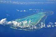 Sɛnea wohu Aldabra ɛwɔ wim.


Nsɛm a wɔde gyinaa so
[sesa]- ↑ Rowlett, Russ. "Lighthouses of Seychelles". The Lighthouse Directory. University of North Carolina at Chapel Hill. Retrieved 2016-09-28.
- ↑ NGA List of Lights – Pub.112 Retrieved 28 September 2016