
File:Soviet topographic map codes.svg

Size of this PNG preview of this SVG file: 251 × 172 pixels. resolutions: 320 × 219 pixels | 640 × 439 pixels | 1,024 × 702 pixels | 1,280 × 877 pixels | 2,560 × 1,754 pixels. Foforɔ
Krataa no ankasa (SVG file, nominally 251 × 172 pixels, file size: 342 KB)
Tɔ fa
| Ɛmu nkyerɛkyere mu |
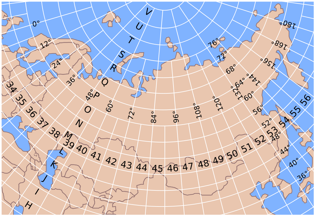
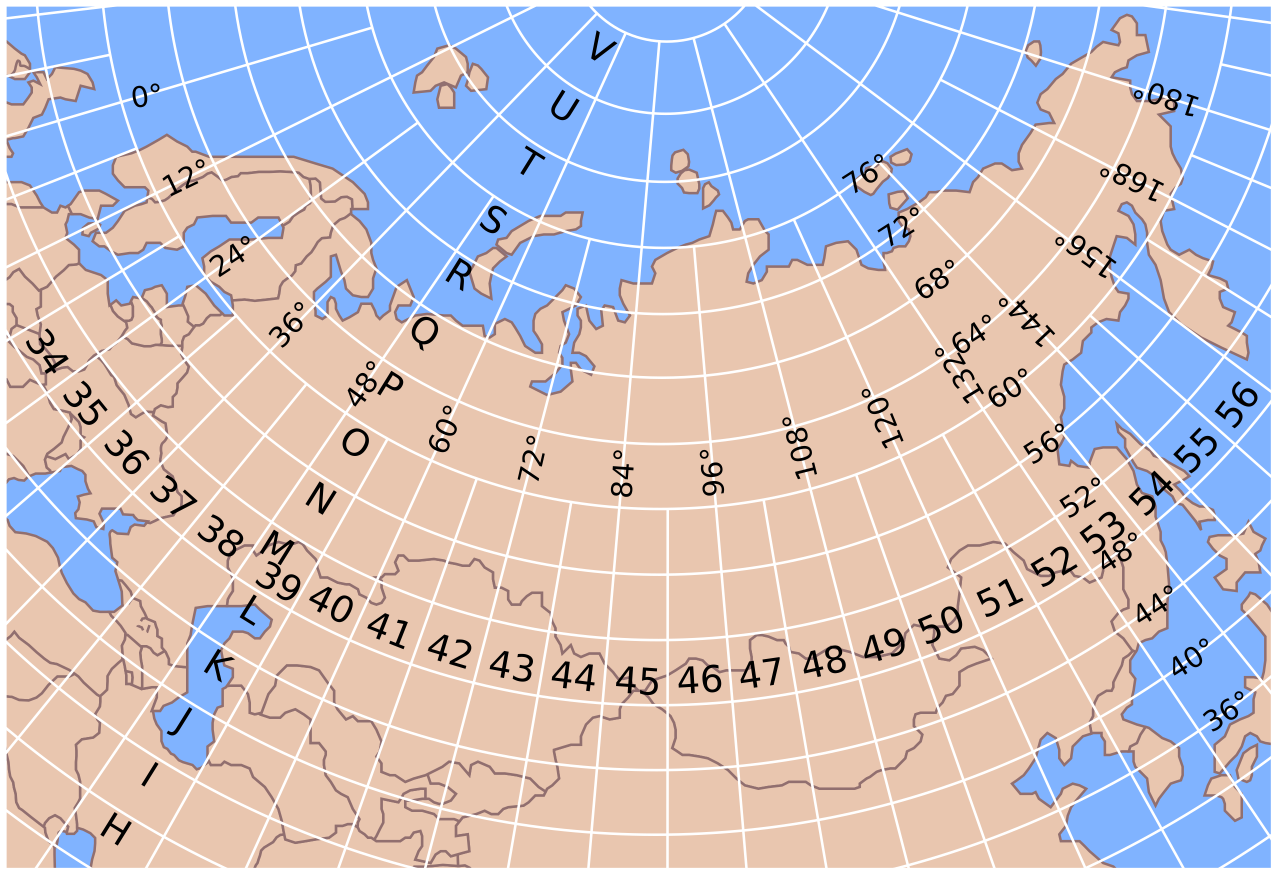
English: Segmentation of the former Soviet territory into 1:1,000,000 topographic map sheets |
| Da | |
| Beaɛ a ɛfiri | Wo ankasa w'adwuma |
| Ɔtwerɛfoɔ | Hellerick |
| SVG genesis |
Tumidie krataa
I, the copyright holder of this work, hereby publish it under the following licenses:
This file is licensed under the Creative Commons Attribution-Share Alike 3.0 Unported license.
- Wo de woho:
- sɛ wo bɛ kyɛ – to copy, distribute and transmit the work
- to remix – Ma dwumadie no mfa
- Ɛwɔ saa mbra yi ase:
- Nea ɛnam so – Ɛsɛ sɛ wo de nnidi, kyerɛ beaɛ a tumidie krataa no wɔ, na san kyerɛ sɛ nsesae bi aba mu anaa. Ɛsɛ sɛ wo kyerɛ ɛwɔ kwan pa so, na ɛmom ɛnyɛ ɔkwan a ɛkyerɛsɛ nea tumidie krataa no yɛ ne de no agye atum sɛ fa yɛ adwuma.
- share alike – If you remix, transform, or build upon the material, you must distribute your contributions under the same or compatible license as the original.

|
Permission is granted to copy, distribute and/or modify this document under the terms of the GNU Free Documentation License, Version 1.2 or any later version published by the Free Software Foundation; with no Invariant Sections, no Front-Cover Texts, and no Back-Cover Texts. A copy of the license is included in the section entitled GNU Free Documentation License. |
Wobɛtumi ayi tumidie krataa a wopɛ
Kratafa ne ho abakɔsɛm
Mia ɛda/berɛ no so na hwɛ sɛnea krataa no baeɛ wo saa berɛ nom
| Da/Mmere | Tɔfabɔ | Akwan ahodoɔ | Odwumdini | Adwenkyerɛ | |
|---|---|---|---|---|---|
| nea ɛkɔ so | 11:37, 27 Oforisuo 2011 | | 251 × 172 (342 KB) | Hellerick | font fix |
| 11:34, 27 Oforisuo 2011 |  | 251 × 172 (241 KB) | Hellerick | fix | |
| 11:31, 27 Oforisuo 2011 |  | 251 × 172 (240 KB) | Hellerick | fix | |
| 11:30, 27 Oforisuo 2011 |  | 251 × 172 (240 KB) | Hellerick | {{Information |Description ={{en|1=Segmentation of the former Soviet territory into 1:1,000,000 topographic map sheets}} |Source ={{own}} |Author =Hellerick |Date =2011-04-27 |Permission = |other_version |
Nkrataa a wɔde di dwuma
Nea ɛdidisoɔ yi kratafa dwumadie this file:
Nea wiase nyinaa de yɛ adwuma
Wikis a edidi so yi de di dwuma:
- Yɛ de ayɛ adwuma wɔ bn.wikipedia.org
- Yɛ de ayɛ adwuma wɔ de.wikipedia.org
- Yɛ de ayɛ adwuma wɔ en.wikipedia.org
- Yɛ de ayɛ adwuma wɔ et.wikipedia.org
- Yɛ de ayɛ adwuma wɔ ja.wikipedia.org
- Yɛ de ayɛ adwuma wɔ ro.wikipedia.org
- Yɛ de ayɛ adwuma wɔ ru.wikipedia.org
- Yɛ de ayɛ adwuma wɔ uk.wikipedia.org
- Yɛ de ayɛ adwuma wɔ vi.wikipedia.org
- Yɛ de ayɛ adwuma wɔ www.wikidata.org