
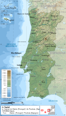
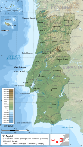
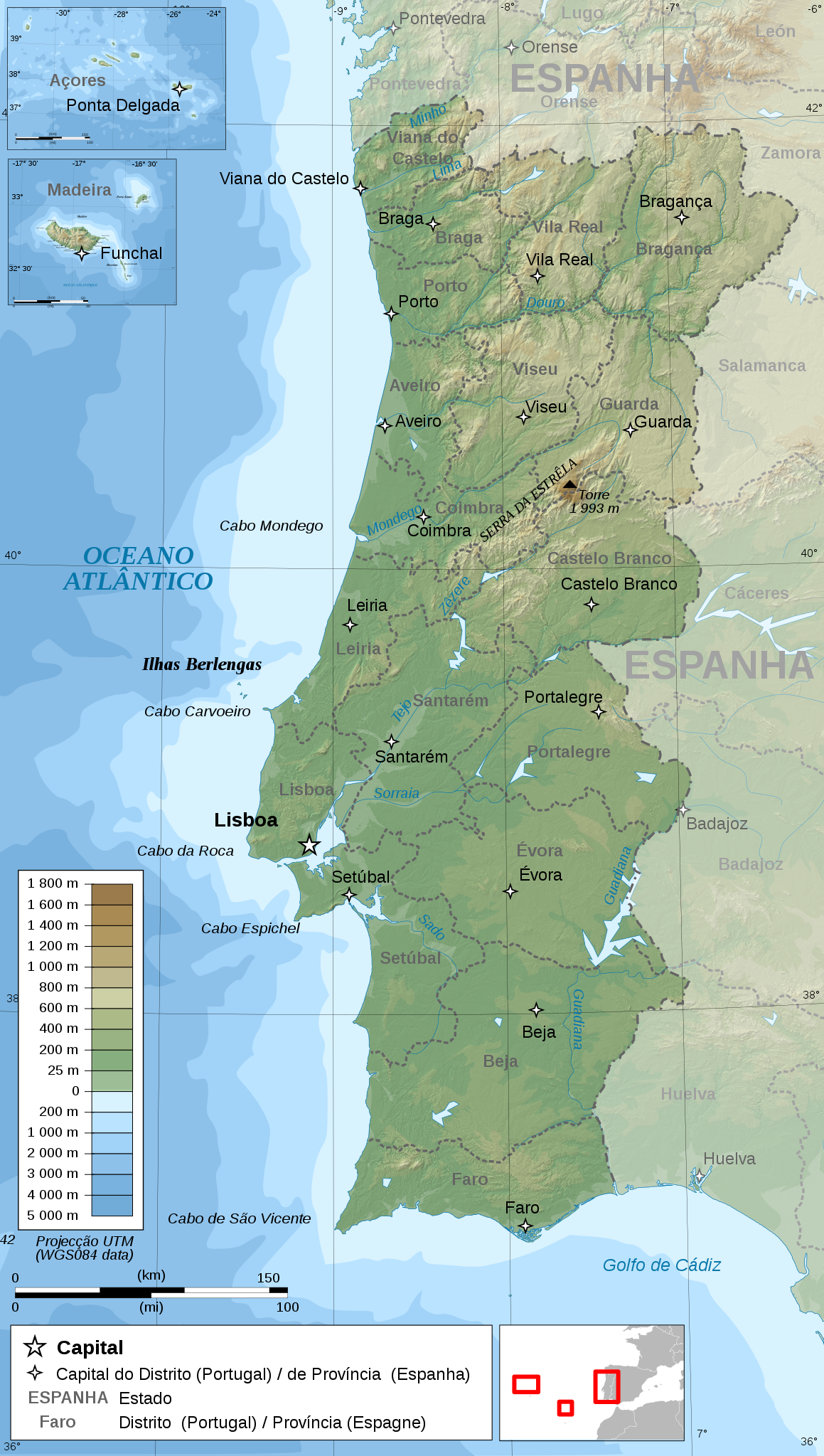
File:Portugal topographic map-pt.svg

Size of this PNG preview of this SVG file: 339 × 599 pixels. resolutions: 136 × 240 pixels | 272 × 480 pixels | 435 × 768 pixels | 579 × 1,024 pixels | 1,159 × 2,048 pixels | 1,738 × 3,070 pixels. Foforɔ
Krataa no ankasa (SVG file, nominally 1,738 × 3,070 pixels, file size: 12.42 MB)
| Ɛmu nkyerɛkyere mu |
Français : Carte topographique et administrative en portugais du Portugal
Português: Carta topográfica e da administração do Portugal, em português
Deutsch: Topographische Karte von Portugal, portugiesische Version English: Topographic and administrative map in Portuguese of Portugal Español: Mapa topográfico y administrativo de Portugal en portugués Italiano: Carta topografica e amministrativa de Portogallo 日本語: ポルトガル語で表示したポルトガル地形·行政地図 |
||
| Da | |||
| Beaɛ a ɛfiri |
English: Own work ;
Français : Création personnelle ;
|
||
| Ɔtwerɛfoɔ | Bourrichon - fr:Bourrichon | ||
| Akwanya (Fa nkrataa no di dwuma biom) |
I, the copyright holder of this work, hereby publish it under the following licenses:
This file is licensed under the Creative Commons Attribution-Share Alike 3.0 Unported, 2.5 Generic, 2.0 Generic and 1.0 Generic license.
Wobɛtumi ayi tumidie krataa a wopɛ |
||
| Other versions |
|


|
This SVG file contains embedded text that can be translated into your language, using any capable SVG editor, text editor or the SVG Translate tool. For more information see: About translating SVG files. |
This W3C-unspecified vector image was created with Inkscape .
Kratafa ne ho abakɔsɛm
Mia ɛda/berɛ no so na hwɛ sɛnea krataa no baeɛ wo saa berɛ nom
| Da/Mmere | Tɔfabɔ | Akwan ahodoɔ | Odwumdini | Adwenkyerɛ | |
|---|---|---|---|---|---|
| nea ɛkɔ so | 20:48, 14 Ayɛwohomumɔ 2009 | | 1,738 × 3,070 (12.42 MB) | Bourrichon | {{Information |Description= {{fr|Carte topographique et administrative en portugais du Portugal}} {{pt|Carta topográfica e da administração do Portugal, em português}} {{de|Topographische Karte von [[:de:Portugal|Port |
Nkrataa a wɔde di dwuma
Nkratafa biara nni hɔ a ɛde wei yɛ adwuma.
Nea wiase nyinaa de yɛ adwuma
Wikis a edidi so yi de di dwuma:
- Yɛ de ayɛ adwuma wɔ br.wiktionary.org
- Yɛ de ayɛ adwuma wɔ hu.wikipedia.org
- Yɛ de ayɛ adwuma wɔ incubator.wikimedia.org
- Yɛ de ayɛ adwuma wɔ it.wiktionary.org
- Yɛ de ayɛ adwuma wɔ mdf.wikipedia.org
- Yɛ de ayɛ adwuma wɔ pt.wikipedia.org
- Lista de rios de Portugal
- Geografia de Portugal
- Regiões de Portugal
- Lista de praias em Portugal
- Lista de ribeiras de Portugal
- Lista de espécies invasoras em Portugal
- Lista de barragens em Portugal
- Floresta portuguesa
- Lista de aves de Portugal
- Lista de anfíbios de Portugal
- Lista de bacias hidrográficas de Portugal
- Ciclo hidrológico em Portugal
- Áreas protegidas de Portugal
- Florestas da Península Ibérica
- Fronteira Espanha–Portugal
- Lista de répteis de Portugal
- Lista de mamíferos de Portugal
- Pontos extremos de Portugal
- Lista de ilhas de Portugal
- Geomonumentos em Portugal
- Mamíferos da península Ibérica
- Lista de cascatas de Portugal
- Botânica em Portugal
- Clima de Portugal
- Lista de municípios de Portugal por população
- Lista de borboletas de Portugal
- Flora de Portugal
- Lista de espécies perigosas em Portugal
- Lista de sismos em Portugal
- Módulo:Mapa de localização/data/Portugal topográfico
- Módulo:Mapa de localização/data/Portugal topográfico/doc
- Lista de vulcões de Portugal
- Usuário:DAR7/Testes/Geografia da Europa/Geografia de Portugal
- Lista de montanhas de Portugal
- Usuário(a):Casadopovo/Eurafrica
- Predefinição:Geografia de Portugal
- Relevo de Portugal
- Yɛ de ayɛ adwuma wɔ sk.wikipedia.org
- Yɛ de ayɛ adwuma wɔ uk.wikipedia.org