File:NASA Satellite Captures Super Bowl Cities - Pawtucket and Foxborough (6813846675).jpg

Krataa no ankasa (2,000 × 2,000 pixels, file size: 7.14 MB, MIME type: image/jpeg)
Nea wo de bɛ yɛ adwuma yi fi Wikimedia Commons na ɛbetumi aba sɛ ɛwɔ dwuma di foforo bi so. Ɛtifi asɛm no ɛtifi asɛm nkyerɛkyerɛmu na ɛwɔ asi no.
Tɔ fa
| Ɛmu nkyerɛkyere muNASA Satellite Captures Super Bowl Cities - Pawtucket and Foxborough (6813846675).jpg |
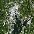
Landsat 7 image of the Pawtucket and Foxborough area in Massachusetts acquired July 31, 2002. Landsat 7 is a U.S. satellite used to acquire remotely sensed images of the Earth's land surface and surrounding coastal regions. It is maintained by the Landsat 7 Project Science Office at the NASA Goddard Space Flight Center in Greenbelt, MD. Landsat satellites have been acquiring images of the Earth’s land surface since 1972. Currently there are more than 2 million Landsat images in the National Satellite Land Remote Sensing Data Archive. For more information visit: landsat.usgs.gov/ To learn more about the Landsat satellite go to: landsat.gsfc.nasa.gov/ Credit: NASA/GSFC/Landsat 7 NASA Goddard Space Flight Center enables NASA’s mission through four scientific endeavors: Earth Science, Heliophysics, Solar System Exploration, and Astrophysics. Goddard plays a leading role in NASA’s accomplishments by contributing compelling scientific knowledge to advance the Agency’s mission. Follow us on Twitter Like us on Facebook Find us on Instagram |
| Da | |
| Beaɛ a ɛfiri | NASA Satellite Captures Super Bowl Cities - Pawtucket and Foxborough |
| Ɔtwerɛfoɔ | NASA Goddard Space Flight Center from Greenbelt, MD, USA |
Tumidie krataa
- Wo de woho:
- sɛ wo bɛ kyɛ – to copy, distribute and transmit the work
- to remix – Ma dwumadie no mfa
- Ɛwɔ saa mbra yi ase:
- Nea ɛnam so – Ɛsɛ sɛ wo de nnidi, kyerɛ beaɛ a tumidie krataa no wɔ, na san kyerɛ sɛ nsesae bi aba mu anaa. Ɛsɛ sɛ wo kyerɛ ɛwɔ kwan pa so, na ɛmom ɛnyɛ ɔkwan a ɛkyerɛsɛ nea tumidie krataa no yɛ ne de no agye atum sɛ fa yɛ adwuma.
| This image was originally posted to Flickr by NASA Goddard Photo and Video at https://flickr.com/photos/24662369@N07/6813846675. It was reviewed on 17 Ɛbɔ 2016 by FlickreviewR and was confirmed to be licensed under the terms of the cc-by-2.0. |
17 Ɛbɔ 2016
| Public domainPublic domainfalsefalse |
| This file is in the public domain in the United States because it was solely created by NASA. NASA copyright policy states that "NASA material is not protected by copyright unless noted". (See Template:PD-USGov, NASA copyright policy page or JPL Image Use Policy.) |  | |
 |
Warnings:
|
Nkyerɛwee
Nneɛma a wɔada no adi wɔ krataa yi mu
depicts English
creator English
Botae bi a enni Wikidata ade
copyright status English
copyrighted English
copyright license English
inception English
3 Ogyefuo 2012
source of file English
file available on the internet English
Kratafa ne ho abakɔsɛm
Mia ɛda/berɛ no so na hwɛ sɛnea krataa no baeɛ wo saa berɛ nom
| Da/Mmere | Tɔfabɔ | Akwan ahodoɔ | Odwumdini | Adwenkyerɛ | |
|---|---|---|---|---|---|
| nea ɛkɔ so | 21:52, 17 Ɛbɔ 2016 |  | 2,000 × 2,000 (7.14 MB) | Vanished Account Byeznhpyxeuztibuo | Transferred from Flickr via Flickr2Commons |
Nkrataa a wɔde di dwuma
Nea ɛdidisoɔ yi kratafa dwumadie this file:
'Metadata'
This file contains additional information, probably added from the digital camera or scanner used to create or digitize it.
If the file has been modified from its original state, some details may not fully reflect the modified file.
| Headline | NASA Satellite Captures Super Bowl Cities - Pawtucket and Foxborough |
|---|---|
| Image title |
|
| Orientation | Normal |
| Horizontal resolution | 300 dpi |
| Vertical resolution | 300 dpi |
| Software used | QuickTime 7.6.6 |
| File change date and time | 16:53, 3 Ogyefuo 2012 |
| Y and C positioning | Centered |
| Exif version | 2.2 |
| Urgency | 1 |
| IIM version | 4 |
