
File:Greater Accra districts.png

Nea wohwɛ yi ne tibea: 800 × 560 pixels. resolutions: 320 × 224 pixels | 640 × 448 pixels | 995 × 696 pixels. Foforɔ
Krataa no ankasa (995 × 696 pixels, file size: 14 KB, MIME type: image/png)
Tɔ fa
| Ɛmu nkyerɛkyere mu |
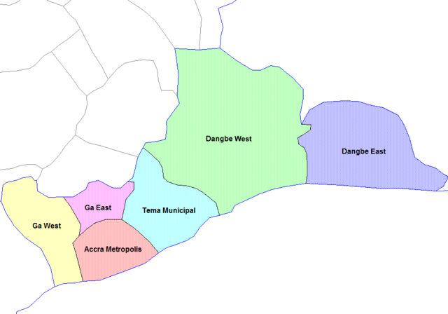
English: Map of the districts of the Greater Accra region of Ghana. Created by Rarelibra for public domain use. Created using MapInfo Professional v7.5 and various mapping resources. |
||||
| Da | 28 Ayɛwohomumɔ 2006 (original upload date) | ||||
| Beaɛ a ɛfiri | Wo ankasa w'adwuma | ||||
| Ɔtwerɛfoɔ | User:Rarelibra | ||||
| Other versions |
|


Tumidie krataa
| I, the copyright holder of this work, release this work into the public domain. This applies worldwide. In some countries this may not be legally possible; if so: I grant anyone the right to use this work for any purpose, without any conditions, unless such conditions are required by law. |
Original upload log
- (del) (cur) 07:36, 5 March 2006 . . Rarelibra (Talk | contribs) . . 1056x816 (29,321 bytes) (Map of the districts of the Greater Accra region of Ghana. Created by Rarelibra for public domain use. Created using MapInfo Professional v7.5 and various mapping resources.)
Kratafa ne ho abakɔsɛm
Mia ɛda/berɛ no so na hwɛ sɛnea krataa no baeɛ wo saa berɛ nom
| Da/Mmere | Tɔfabɔ | Akwan ahodoɔ | Odwumdini | Adwenkyerɛ | |
|---|---|---|---|---|---|
| nea ɛkɔ so | 14:00, 6 Ɔpɛpɔn 2021 | | 995 × 696 (14 KB) | Jakob Gottfried | cropped |
| 10:52, 28 Ayɛwohomumɔ 2006 |  | 1,056 × 816 (29 KB) | Ahanta | from:en:Districts of ghana Map of the districts of the Greater Accra region of Ghana. Created by Rarelibra for public domain use. Created using MapInfo Professional v7.5 and various mapping resources. [edit] I, the creator of this work, hereby release it |
Nkrataa a wɔde di dwuma
Nea ɛdidisoɔ yi kratafa dwumadie this file:
Nea wiase nyinaa de yɛ adwuma
Wikis a edidi so yi de di dwuma:
- Yɛ de ayɛ adwuma wɔ cs.wikipedia.org
- Yɛ de ayɛ adwuma wɔ dag.wikipedia.org
- Yɛ de ayɛ adwuma wɔ de.wikipedia.org
- Yɛ de ayɛ adwuma wɔ en.wikipedia.org
- Yɛ de ayɛ adwuma wɔ es.wikipedia.org
- Yɛ de ayɛ adwuma wɔ fr.wikipedia.org
- Yɛ de ayɛ adwuma wɔ it.wikipedia.org
- Yɛ de ayɛ adwuma wɔ ko.wikipedia.org
- Yɛ de ayɛ adwuma wɔ nl.wikipedia.org
- Yɛ de ayɛ adwuma wɔ pl.wikipedia.org
- Yɛ de ayɛ adwuma wɔ pt.wikipedia.org
- Yɛ de ayɛ adwuma wɔ ro.wikipedia.org
- Yɛ de ayɛ adwuma wɔ tr.wikipedia.org
- Yɛ de ayɛ adwuma wɔ uk.wikipedia.org