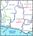
File:Fort Ruijghaver 010.svg
Appearance

Size of this PNG preview of this SVG file: 554 × 599 pixels. resolutions: 222 × 240 pixels | 444 × 480 pixels | 710 × 768 pixels | 947 × 1,024 pixels | 1,894 × 2,048 pixels | 727 × 786 pixels. Foforɔ
Krataa no ankasa (SVG file, nominally 727 × 786 pixels, file size: 384 KB)
Kratafa ne ho abakɔsɛm
Mia ɛda/berɛ no so na hwɛ sɛnea krataa no baeɛ wo saa berɛ nom
| Da/Mmere | Tɔfabɔ | Akwan ahodoɔ | Odwumdini | Adwenkyerɛ | |
|---|---|---|---|---|---|
| nea ɛkɔ so | 20:22, 9 Ɔpɛnimma 2011 |  | 727 × 786 (384 KB) | Katharinaiv | {{Information |Description ={{en|1=Map to the possible location of the Dutch fort Ruijghaver, 1654 - 1660, at the river Akobra.}} {{de|1=Karte zur möglichen Lage des holländischen Forts Ruijghaver, 1654 - 1660, am Akobrafluss.}} |Source ={{ow |
Nkrataa a wɔde di dwuma
Nea ɛdidisoɔ yi kratafa dwumadie this file:
Nea wiase nyinaa de yɛ adwuma
Wikis a edidi so yi de di dwuma:
- Yɛ de ayɛ adwuma wɔ de.wikipedia.org
- Yɛ de ayɛ adwuma wɔ en.wikipedia.org
- Yɛ de ayɛ adwuma wɔ es.wikipedia.org
- Yɛ de ayɛ adwuma wɔ fr.wikipedia.org
- Yɛ de ayɛ adwuma wɔ ha.wikipedia.org
- Yɛ de ayɛ adwuma wɔ it.wikipedia.org
- Yɛ de ayɛ adwuma wɔ nl.wikipedia.org
- Yɛ de ayɛ adwuma wɔ www.wikidata.org
