
File:Eyjafjallajökull.jpeg

Nea wohwɛ yi ne tibea: 800 × 536 pixels. resolutions: 320 × 214 pixels | 640 × 429 pixels | 1,024 × 686 pixels | 1,280 × 858 pixels | 2,960 × 1,983 pixels. Foforɔ
Krataa no ankasa (2,960 × 1,983 pixels, file size: 3.96 MB, MIME type: image/jpeg)
| Ɛmu nkyerɛkyere mu |
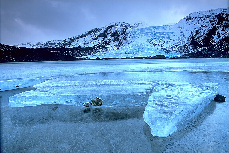
English: Gígjökull, an outlet glacier extending from Eyjafjallajökull, Iceland. Lónið is the lake visible in the foreground.
Tiếng Việt: Sông băng Eyjafjallajökull tại Iceland.
Photo was taken using the following technique:
|
||
| Da | 2003-02-13, 11:00–12:00 | ||
| Beaɛ a ɛfiri |
Wo ankasa w'adwuma: http://fam-tille.de/sparetime.html |
||
| Ɔtwerɛfoɔ | Andreas Tille | ||
| Akwanya (Fa nkrataa no di dwuma biom) |
Quote of http://fam-tille.de/island/winter/0213/2003_093.html - Permission is granted to copy, distribute and/or modify this images under the terms of the GNU Free Documentation License, Version 1.1 or any later version published by the Free Software Foundation. I, the copyright holder of this work, hereby publish it under the following licenses:
This file is licensed under the Creative Commons Attribution-Share Alike 3.0 Unported, 2.5 Generic, 2.0 Generic and 1.0 Generic license.
Wobɛtumi ayi tumidie krataa a wopɛ |

| Camera location | | View this and other nearby images on: OpenStreetMap |
|---|
| Annotations | This image is annotated: View the annotations at Commons |
Assessment
|
This image was selected as picture of the day on Wikimedia Commons for 21 December 2004. It was captioned as follows: Other languages:
Esperanto: Glaciejo Eyjafjallajökull en Islando |
This image was selected as picture of the day on Vietnamese Wikipedia.
|
Kratafa ne ho abakɔsɛm
Mia ɛda/berɛ no so na hwɛ sɛnea krataa no baeɛ wo saa berɛ nom
| Da/Mmere | Tɔfabɔ | Akwan ahodoɔ | Odwumdini | Adwenkyerɛ | |
|---|---|---|---|---|---|
| nea ɛkɔ so | 12:01, 2 Ɔpɛnimma 2004 | | 2,960 × 1,983 (3.96 MB) | Ævar Arnfjörð Bjarmason |
Nkrataa a wɔde di dwuma
Nkratafa biara nni hɔ a ɛde wei yɛ adwuma.
Nea wiase nyinaa de yɛ adwuma
Wikis a edidi so yi de di dwuma:
- Yɛ de ayɛ adwuma wɔ af.wikipedia.org
- Yɛ de ayɛ adwuma wɔ an.wikipedia.org
- Yɛ de ayɛ adwuma wɔ arc.wikipedia.org
- Yɛ de ayɛ adwuma wɔ ar.wikipedia.org
- Yɛ de ayɛ adwuma wɔ arz.wikipedia.org
- Yɛ de ayɛ adwuma wɔ azb.wikipedia.org
- Yɛ de ayɛ adwuma wɔ be.wikipedia.org
- Yɛ de ayɛ adwuma wɔ bg.wikipedia.org
- Yɛ de ayɛ adwuma wɔ bg.wikinews.org
- Yɛ de ayɛ adwuma wɔ bo.wikipedia.org
- Yɛ de ayɛ adwuma wɔ br.wikipedia.org
- Yɛ de ayɛ adwuma wɔ bs.wikipedia.org
- Yɛ de ayɛ adwuma wɔ ca.wikipedia.org
- Yɛ de ayɛ adwuma wɔ co.wikipedia.org
- Yɛ de ayɛ adwuma wɔ cs.wikipedia.org
- Yɛ de ayɛ adwuma wɔ da.wikipedia.org
- Yɛ de ayɛ adwuma wɔ de.wikipedia.org
- Eisscholle
- Benutzer:Rainbowfish/Test10
- Wikipedia:Kandidaten für exzellente Bilder/Archiv2005/7
- Wikipedia:Archiv/Hilfe:MediaWiki/Versionen
- Benutzer:Torinberl/Testterrain
- Benutzer:Torinberl/Benutzerseite
- Portal Diskussion:Island/Bild des Monats
- Benutzer Diskussion:Placebo111
- Portal Diskussion:Island/Bild des Monats/Archiv/2006
- Benutzer:Rainbowfish/Bilder
- Benutzer:Rainbowfish/ALT
- Portal Diskussion:Vulkane/Vulkanbild der Woche
- Yɛ de ayɛ adwuma wɔ de.wiktionary.org
- Yɛ de ayɛ adwuma wɔ dsb.wikipedia.org
- Yɛ de ayɛ adwuma wɔ el.wikipedia.org
- Yɛ de ayɛ adwuma wɔ en.wikipedia.org
View more global usage of this file.