
File:EU Pop2008 1024.PNG

Nea wohwɛ yi ne tibea: 600 × 599 pixels. resolutions: 240 × 240 pixels | 481 × 480 pixels | 769 × 768 pixels | 1,025 × 1,024 pixels | 1,536 × 1,534 pixels. Foforɔ
Krataa no ankasa (1,536 × 1,534 pixels, file size: 249 KB, MIME type: image/png)

|
This demographic map image could be re-created using vector graphics as an SVG file. This has several advantages; see Commons:Media for cleanup for more information. If an SVG form of this image is available, please upload it and afterwards replace this template with
{{vector version available|new image name}}.
It is recommended to name the SVG file “EU Pop2008 1024.svg”—then the template Vector version available (or Vva) does not need the new image name parameter. |
Tɔ fa
| Ɛmu nkyerɛkyere mu |
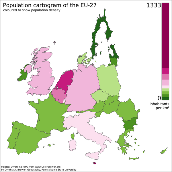
English: A preliminary population cartogram of the EU-27 made with ScapeToad 1.1 using a cut-down and reprojected public domain world shapefile (projection: Lambert Azimuthal Equal Area) and January 2008 population data from Eurostat. This version includes Dutch barrier islands. |
| Da | |
| Beaɛ a ɛfiri | Wo ankasa w'adwuma |
| Ɔtwerɛfoɔ | Vinny Burgoo |
| Other versions | Derivative works of this file: EU Pop2008 1024 new.png |
See also Geoilex's EU cartogram.
Tumidie krataa
| I, the copyright holder of this work, release this work into the public domain. This applies worldwide. In some countries this may not be legally possible; if so: I grant anyone the right to use this work for any purpose, without any conditions, unless such conditions are required by law. |
Kratafa ne ho abakɔsɛm
Mia ɛda/berɛ no so na hwɛ sɛnea krataa no baeɛ wo saa berɛ nom
| Da/Mmere | Tɔfabɔ | Akwan ahodoɔ | Odwumdini | Adwenkyerɛ | |
|---|---|---|---|---|---|
| nea ɛkɔ so | 17:04, 11 Obubuo 2012 | | 1,536 × 1,534 (249 KB) | Veikk0.ma | Optimised with OptiPNG. |
| 18:42, 27 Kitawonsa 2008 |  | 1,536 × 1,534 (366 KB) | Vinny Burgoo | {{Information |Description= |Source= |Date= |Author= |Permission= |other_versions= }} | |
| 23:12, 14 Kitawonsa 2008 |  | 1,054 × 1,024 (210 KB) | Vinny Burgoo | {{Information |Description= |Source= |Date= |Author= |Permission= |other_versions= }} | |
| 01:43, 14 Ayɛwohomumɔ 2008 |  | 1,024 × 1,024 (233 KB) | Vinny Burgoo | {{Information |Description= |Source= |Date= |Author= |Permission= |other_versions= }} | |
| 19:55, 6 Ayɛwohomumɔ 2008 |  | 1,024 × 768 (61 KB) | Vinny Burgoo | {{Information |Description={{en|1=A preliminary population cartogram of the EU-27 made with [http://chorogram.choros.ch/scapetoad/ ScapeToad] and data and shapefiles from ... can't remember.}} |Source=Own work by uploader |Author=[[User:Vinny Burgoo|Vinny |
Nkrataa a wɔde di dwuma
Nea ɛdidisoɔ yi kratafa dwumadie this file:
Nea wiase nyinaa de yɛ adwuma
Wikis a edidi so yi de di dwuma:
- Yɛ de ayɛ adwuma wɔ af.wikipedia.org
- Yɛ de ayɛ adwuma wɔ ar.wikipedia.org
- Yɛ de ayɛ adwuma wɔ cs.wikipedia.org
- Yɛ de ayɛ adwuma wɔ en.wikipedia.org
- Yɛ de ayɛ adwuma wɔ fi.wikipedia.org
- Yɛ de ayɛ adwuma wɔ gu.wikipedia.org
- Yɛ de ayɛ adwuma wɔ hi.wikipedia.org
- Yɛ de ayɛ adwuma wɔ it.wikipedia.org
- Yɛ de ayɛ adwuma wɔ ja.wikipedia.org
- Yɛ de ayɛ adwuma wɔ ms.wikipedia.org
- Yɛ de ayɛ adwuma wɔ pt.wikipedia.org
- Yɛ de ayɛ adwuma wɔ sv.wikipedia.org
- Yɛ de ayɛ adwuma wɔ ta.wikipedia.org
- Yɛ de ayɛ adwuma wɔ uk.wikipedia.org
- Yɛ de ayɛ adwuma wɔ ur.wikipedia.org