
File:Brong Ahafo districts.png

Nea wohwɛ yi ne tibea: 776 × 600 pixels. resolutions: 311 × 240 pixels | 621 × 480 pixels | 994 × 768 pixels | 1,056 × 816 pixels. Foforɔ
Krataa no ankasa (1,056 × 816 pixels, file size: 49 KB, MIME type: image/png)
Tɔ fa
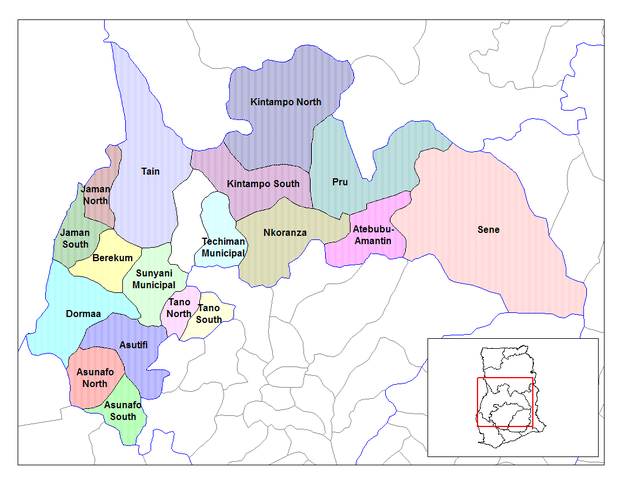
| Ɛmu nkyerɛkyere mu | Map of the districts of the Brong Ahafo region of Ghana. Created by Rarelibra for public domain use. Created using MapInfo Professional v7.5 and various mapping resources. |
| Da | 28 Ayɛwohomumɔ 2006 (original upload date) |
| Beaɛ a ɛfiri | No machine-readable source provided. Own work assumed (based on copyright claims). |
| Ɔtwerɛfoɔ | No machine-readable author provided. Ahanta assumed (based on copyright claims). |
Tumidie krataa
| I, the copyright holder of this work, release this work into the public domain. This applies worldwide. In some countries this may not be legally possible; if so: I grant anyone the right to use this work for any purpose, without any conditions, unless such conditions are required by law. |
Kratafa ne ho abakɔsɛm
Mia ɛda/berɛ no so na hwɛ sɛnea krataa no baeɛ wo saa berɛ nom
| Da/Mmere | Tɔfabɔ | Akwan ahodoɔ | Odwumdini | Adwenkyerɛ | |
|---|---|---|---|---|---|
| nea ɛkɔ so | 10:27, 28 Ayɛwohomumɔ 2006 | | 1,056 × 816 (49 KB) | Ahanta | Map of the districts of the Brong Ahafo region of Ghana. Created by Rarelibra for public domain use. Created using MapInfo Professional v7.5 and various mapping resources. [edit] I, the creator of this work, hereby release it into the public domain. This |
Nkrataa a wɔde di dwuma
Nea ɛdidisoɔ yi kratafa dwumadie this file:
Nea wiase nyinaa de yɛ adwuma
Wikis a edidi so yi de di dwuma:
- Yɛ de ayɛ adwuma wɔ ca.wikipedia.org
- Yɛ de ayɛ adwuma wɔ ceb.wikipedia.org
- Yɛ de ayɛ adwuma wɔ dag.wikipedia.org
- Yɛ de ayɛ adwuma wɔ da.wikipedia.org
- Yɛ de ayɛ adwuma wɔ de.wikipedia.org
- Yɛ de ayɛ adwuma wɔ dga.wikipedia.org
- Yɛ de ayɛ adwuma wɔ en.wikipedia.org
- Dormaa District
- Asutifi District
- Nkoranza District
- Sene District
- Atebubu District
- Pru District
- Jaman District
- Berekum-Jaman District
- Kintampo District
- Asunafo District
- User talk:Rarelibra/Maps2
- List of hospitals in Ghana
- List of Ghana Parliament constituencies
- Nsoatre
- User:GerardM/Districts of Ghana
- Tano District, Ghana
- Yɛ de ayɛ adwuma wɔ es.wikipedia.org
- Yɛ de ayɛ adwuma wɔ fa.wikipedia.org
- Yɛ de ayɛ adwuma wɔ frr.wikipedia.org
- Yɛ de ayɛ adwuma wɔ fr.wikipedia.org
View more global usage of this file.