
File:Bangladesh divisions english.png
Nea wohwɛ yi ne tibea: 439 × 599 pixels. resolutions: 176 × 240 pixels | 500 × 682 pixels. Foforɔ
Krataa no ankasa (500 × 682 pixels, file size: 19 KB, MIME type: image/png)
Tɔ fa
| Ɛmu nkyerɛkyere mu |
Español: Divisiones de Bangladesh
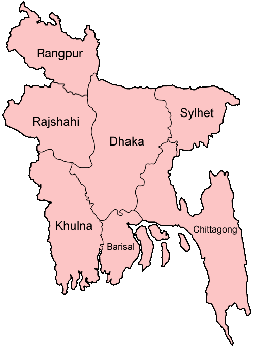
Map of the divisions of Bangladesh in English. Made by User:Golbez. |
| Da | 31 Ɔpɛnimma 2005 (original upload date) |
| Beaɛ a ɛfiri | No machine-readable source provided. Own work assumed (based on copyright claims). |
| Ɔtwerɛfoɔ | No machine-readable author provided. Golbez assumed (based on copyright claims). |
derivative works
Derivative works of this file: Bangladesh location map-Rangpur Division.svg
Tumidie krataa
I, the copyright holder of this work, hereby publish it under the following licenses:

|
Permission is granted to copy, distribute and/or modify this document under the terms of the GNU Free Documentation License, Version 1.2 or any later version published by the Free Software Foundation; with no Invariant Sections, no Front-Cover Texts, and no Back-Cover Texts. A copy of the license is included in the section entitled GNU Free Documentation License. |
| This file is licensed under the Creative Commons Attribution-Share Alike 3.0 Unported license. | ||
| ||
| This licensing tag was added to this file as part of the GFDL licensing update. |
This file is licensed under the Creative Commons Attribution 2.5 Generic license.
- Wo de woho:
- sɛ wo bɛ kyɛ – to copy, distribute and transmit the work
- to remix – Ma dwumadie no mfa
- Ɛwɔ saa mbra yi ase:
- Nea ɛnam so – Ɛsɛ sɛ wo de nnidi, kyerɛ beaɛ a tumidie krataa no wɔ, na san kyerɛ sɛ nsesae bi aba mu anaa. Ɛsɛ sɛ wo kyerɛ ɛwɔ kwan pa so, na ɛmom ɛnyɛ ɔkwan a ɛkyerɛsɛ nea tumidie krataa no yɛ ne de no agye atum sɛ fa yɛ adwuma.
Wobɛtumi ayi tumidie krataa a wopɛ
Kratafa ne ho abakɔsɛm
Mia ɛda/berɛ no so na hwɛ sɛnea krataa no baeɛ wo saa berɛ nom
| Da/Mmere | Tɔfabɔ | Akwan ahodoɔ | Odwumdini | Adwenkyerɛ | |
|---|---|---|---|---|---|
| nea ɛkɔ so | 19:40, 27 Ɔpɛpɔn 2010 | | 500 × 682 (19 KB) | NordNordWest | update Rangpur |
| 00:28, 1 Ɔbɛnem 2009 |  | 500 × 682 (19 KB) | Mahahahaneapneap | Compressed | |
| 02:52, 31 Ɔpɛnimma 2005 |  | 500 × 682 (20 KB) | Golbez | Map of the divisions of Bangladesh in English. Made by User:Golbez. Category:Maps of Bangladesh |
Nkrataa a wɔde di dwuma
Nkratafa biara nni hɔ a ɛde wei yɛ adwuma.
Nea wiase nyinaa de yɛ adwuma
Wikis a edidi so yi de di dwuma:
- Yɛ de ayɛ adwuma wɔ ar.wikipedia.org
- Yɛ de ayɛ adwuma wɔ ast.wikipedia.org
- Yɛ de ayɛ adwuma wɔ ca.wikipedia.org
- Yɛ de ayɛ adwuma wɔ de.wikipedia.org
- Yɛ de ayɛ adwuma wɔ en.wikipedia.org
- Wikipedia:WikiProject Bangladesh
- Wikipedia:WikiProject Bangladesh/History Workgroup
- User:Jonny-mt/Gallery of current first-level administrative country subdivisions maps
- Wikipedia:WikiProject Bangladesh/Geography Workgroup
- Talk:Bangladesh/Archive 3
- Wikipedia:WikiProject Bangladesh/ResourcesBangladesh
- Wikipedia:Graphics Lab/Map workshop/Archive/Aug 2010
- Yɛ de ayɛ adwuma wɔ eo.wikipedia.org
- Yɛ de ayɛ adwuma wɔ fi.wikipedia.org
- Yɛ de ayɛ adwuma wɔ fr.wikipedia.org
- Yɛ de ayɛ adwuma wɔ gl.wikipedia.org
- Yɛ de ayɛ adwuma wɔ hi.wikipedia.org
- बांग्लादेश
- सिलहट विभाग
- चट्टग्राम विभाग
- ढाका जिला
- ढाका विभाग
- राजशाही विभाग
- खुलना विभाग
- बरिशाल विभाग
- नरसिंगडी जिला
- मानिकगंज जिला
- मुंशीगंज जिला
- नारायनगंज जिला
- मैमनसिंह जिला
- शेरपुर जिला
- जमालपुर जिला
- नेत्रोकोना जिला
- गाजीपुर जिला (बांग्लादेश)
- किशोरगंज जिला
- टंगाइल जिला
- फरीदपुर जिला
- मदारीपुर जिला
- शरियतपुर जिला
- राजबाड़ी जिला
- बगेरहाट जिला
- चौडांगा जिला
- येशोर जिला
- झेनईदह जिला
- खुलना जिला
- कुश्तिया जिला
- मगुरा जिला
- मेहरपुर जिला
View more global usage of this file.